


Garmin GPSMAP 79s – Marine Handheld with Worldwide Basemap
Stok 5
The Garmin GPSMAP® 79s is a rugged handheld marine GPS designed for boating and sailing, featuring a floatable waterproof design, built-in compass
Status Barang: Ready
Kondisi: Baru
Rp5.300.000,0
Stok 5
Gamin GPSMAP 79s
Marine Handheld with Worldwide Basemap
OVERVIEW:
The GPSMAP 79s with a built-in worldwide basemap and support for downloadable marine charts. In addition to a 3-axis tilt-compensated compass, GPSMAP 79 marine handhelds use reliable GNSS with support for multiple constellations which allows boaters to access data across the world.
FEATURES:
◆ Rugged Handheld
◆ Designed to Float
◆ Accurate Tracking
◆ Increased Memory
◆ Built-In Compass
SPEC’s:
General
◆ Display resolution: 240 x 400 pixels
◆ Display Type: transflective, 65K color TFT
◆ Battery type: 2 AA batteries (not included); NiMH or Lithium recommended
◆ Battery life: up to 19 hours
◆ Waterproof: IPX7
◆ MIL-STD-810: Yes (thermal, shock, water); bare unit only
◆ Interface: high speed micro-USB and NMEA 0183 compatible
◆ Internal Memory: 8 GB
Maps & Memory
◆ Ability to add maps
◆ Basemap
◆ Map segments: 15000
◆ External memory storage: Yes (32 GB max microSD card, not included)
◆ Waypoints/favorites/locations: 10000
◆ Tracks: 250
◆ Navigation Track Log: 20,000 points, 250 saved gpx tracks, 300 saved fit activities
◆ Navigation Routes: 250, 250 points per route; 50 points auto routing
◆ Rinex logging
Sensors
◆ High-sensitivity receiver
◆ GPS
◆ GLONASS
◆ Galileo
◆ QZSS
◆ SBAS
◆ Compass: Yes (tilt-compensated 3-axis)
◆ GPS compass (while moving)
Outdoor Recreation
◆ Point-to-point navigation
◆ Area calculation
◆ Hunt/fish calendar
◆ Geocaching-friendly: Yes (Paperless)
◆ Custom maps compatible
◆ Picture viewer
EACH UNIT INCLUDES WITH:
◆ GPSMAP 79s
◆ Lanyard
◆ USB cable
◆ Documentation
| Berat | 1 kg |
|---|
General |
|
| Lens Material | chemically strengthened glass |
|---|---|
| Dimension | 2.67” x 6.85” x 1.67” (6.77 x 17.40 x 4.23 cm) |
| Weight | 9.95 oz (282g) with batteries |
| Water rating | IPX7 |
| MIL-STD-810 | yes (thermal, shock, water); bare unit only |
| Display Type | transflective, 65K color TFT |
| Display Size | 1.5″W x 2.5″H (3.8 x 6.3 cm); 3″ diag (7.6 cm) |
| Display resolution | 240 x 400 pixels |
| Battery Type | 2 AA batteries (not included); NiMH or Lithium recommended |
| Battery life | up to 19 hours |
| Memory/History | 8 GB (user space varies based on included mapping on sc version) |
| Interface | high speed microUSB and NMEA 0183 compatible |
Maps & Memory |
|
| Preloaded maps | Available on sc version only |
|---|---|
| Ability to add maps | ✅ |
| Basemap | ✅ |
| Automatic routing (turn by turn routing on roads) for outdoor activities | Yes (with optional mapping for detailed roads) |
| Map segments | 15,000 |
| Includes detailed hydrographic features (coastlines, lake/river shorelines, wetlands and perennial and seasonal streams) | Yes (downloadable from Garmin Express™) |
| Includes searchable points of interests (parks, campgrounds, scenic lookouts and picnic sites) | Yes (downloadable from Garmin Express™) |
| Displays national, state and local parks, forests, and wilderness areas | Yes (downloadable from Garmin Express™) |
| External memory storage | yes (32 GB max microSD™ card) |
| Waypoints/favorites/locations | 10,000 |
| Courses | 250, 200 course points per course |
| Tracks | 250 |
| Navigation Track Log | 20,000 points, 250 saved gpx tracks, 300 saved fit activities |
| Navigation Routes | 250, 250 points per route; 50 points auto routing |
| Rinex logging | ✅ |
Sensors |
|
| GPS | ✅ |
|---|---|
| Galileo | ✅ |
| QZSS | ✅ |
| SBAS | ✅ |
| Compass | Yes (tilt-compensated 3-axis) |
| High-sensitivity receiver | ✅ |
| GPS compass (while moving) | ✅ |
Outdoor Recreation |
|
| Point-to-point navigation | ✅ |
|---|---|
| Area calculation | ✅ |
| Fish forecast | ✅ |
| Geocaching-friendly | Yes (Paperless) |
| Custom maps compatible | ✅ |
| Picture viewer | ✅ |
Based on 0 reviews
Be the first to review “Garmin GPSMAP 79s – Marine Handheld with Worldwide Basemap”
Produk Terkait
-
Ready StockHandheld GPS
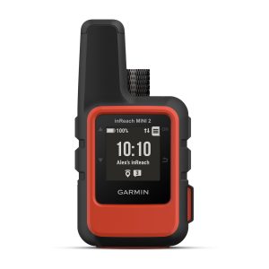
Garmin inReach Mini 2 Flame Red – Compact Satellite Communicator (NON TAM)
The Garmin inReach Mini 2 is a rugged, palm-sized satellite communicator that keeps you connected wherever your adventures take you. Whether hiking, sailing, or exploring remote areas, it provides peace of mind with global coverage, SOS alerts, and two-way messaging—all in a lightweight design.
SKU: 010-02602-20 -
Ready StockHandheld GPS
Garmin GPSMAP 65s – Multi-Band GPS Handheld with Sensors
The Garmin GPSMAP 65s is a rugged handheld GPS built for hikers, explorers, and outdoor enthusiasts who demand accuracy and reliability in challenging environments. With advanced multi-band GNSS support, preloaded maps, and ABC sensors, it ensures you stay on track wherever your adventure takes you.
SKU: 010-02451-15 -
Pre-OrderHandheld GPS
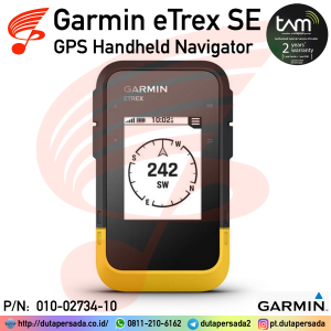
Garmin GPS eTrex SE – GPS Handheld Navigator
The Garmin eTrex SE is a rugged, entry-level handheld GPS designed for hiking, geocaching, and outdoor adventures, offering long battery life, multi-GNSS support, and wireless connectivity at an affordable price. It’s essentially the modern replacement for the older eTrex 10, but with upgraded features and usability.
SKU: 010-02734-10 -
Pre-OrderHandheld GPS
Garmin GPSMAP H1 – Premium GPS Handheld Touchscreen
The Garmin GPSMAP H1 is a tough, reliable handheld GPS designed for outdoor recreation, trekking, and exploration. Built with advanced satellite support and long battery life, it ensures accurate navigation even in the most challenging environments.
SKU: 010-02920-13


There are no reviews yet.